A Walk Round the Point
A Tessa Bunney Photograph
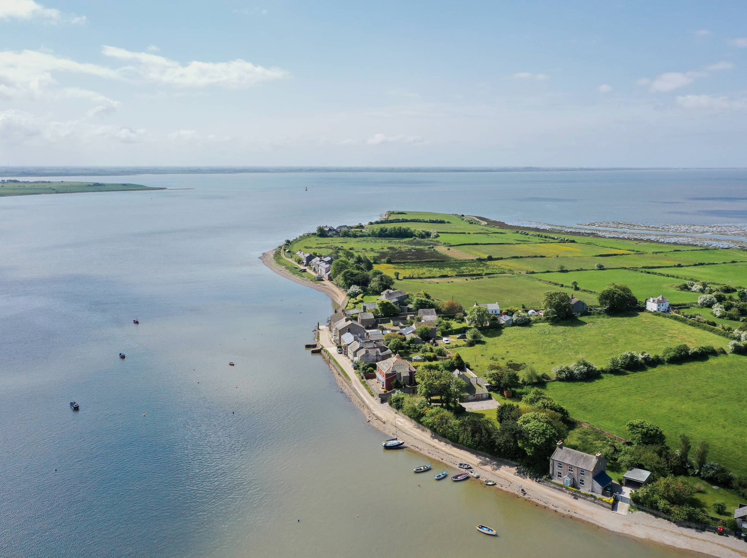
A short walk exploring a unique peninsula where the estuary of the river Lune meets Morecambe Bay. Most of Sunderland Point is a conservation area and many houses grade 2 listed.
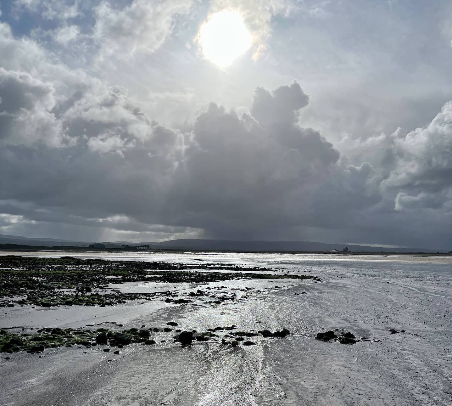
Historic Sunderland Point is unusual, intriguing and mysterious. Walking around the Point and through the village, a strong sense of place emerges, the mudflats and salt marsh, the river, sea, hills and the big, big skies.
Step back in time among the 18th century buildings that served as Lancaster’s first transatlantic port.
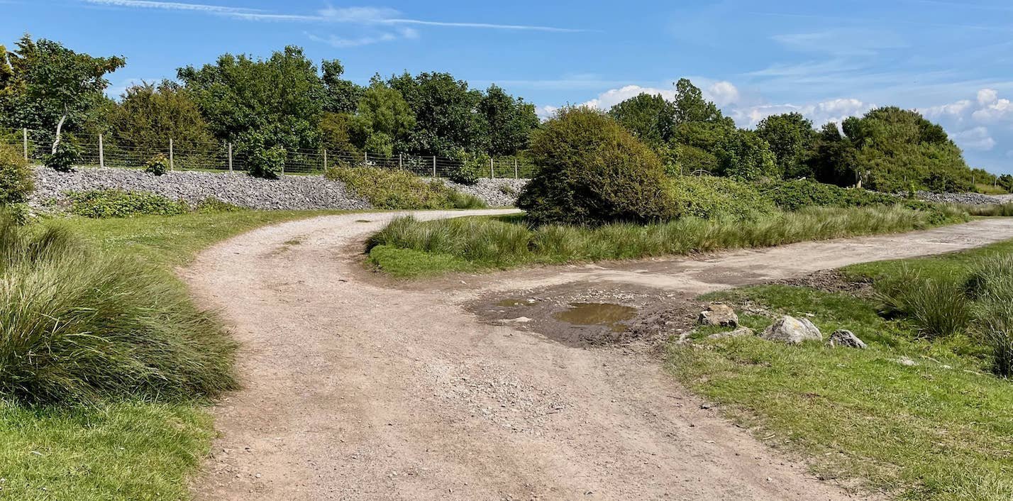
Route of the Walk
Map Courtesy Ordnance Survey
Points of Interest
01 Potts Corner
02 Salt Marsh and ‘Baxter’s Rails’
03 Bird Hide and the Horizon Line Chamber
04 The Gravesite
05 Point End and Plover Scar Lighthouse
06 Old Hall (or Sunderland Hall)
07 Fish House and Net Posts
08 Cotton Tree Cottage and Cotton Tree
09 The Big House, Reading Room and Second Terrace
10 The Ship Inn, Stone Pillar and First Terrace.
11 The Causeway
12 Upsteps Cottage
13 Mission Church and the Summer House
14 Pillboxes and old Tram
Essential Information
Location: Sunderland Point, Morecambe, Lancashire
Start and finish point: Pott’s Corner, end of Carr Lane, Middleton, Morecambe (nearest postcode LA3 3LL)
Grid reference: SD 41327 57220
Approximately three and half miles, allow one hour and fifteen minutes.
Getting there: Follow signs off Middleton Road for Middleton Towers Retirement Village. The road twists and turns and has a cul-de-sac sign but keep on Carr Lane and you will soon reach the car park at the end by the sands.
WARNING: While this trail does not use the tidal causeway to Sunderland Point, the pathway can be covered by high tides. Always consult the tide table for Heysham and remember weather conditions affect the timing and height of the tide.
Don’t be put off. Calm consideration and caution are strongly recommended.
Special Advice
Dogs on Leads Please: This walk is over a highly protected seascape important for wading birds on the feeding grounds of Morecambe Bay. It is also adjacent to livestock farmland, cattle could be met face to face. There are gates to be opened and closed.
Stout Shoes or Boots: The path is mostly easy walking, but the shore is uneven and often churned by cattle grazing on the marsh. It can be very muddy when wet. Around the Point End the route is stony and slippery after rain or the tide and will be unstable for those with impaired mobility.
Shops: Sorry but there are no shops or other refreshment facilities at the Point. There are public toilets, lovingly cared for by village residents. There is a well stocked shop and cafe at Potts Corner with soft drinks, crisps and ice creams.
Private Property and Homes: All of the Point is privately owned and while visitors are welcomed, consideration for privacy is greatly appreciated.
Start of the walk
Just a minute - before we start – shortly before arriving at Potts Corner you will have seen the large sign ‘Middleton Towers’. This is the site of the old Middleton Towers Holiday Camp. Opened in 1939 – and immediately requisitioned for war use – it was one of the largest in the country covering some 65 acres. Famous for its ocean liner styled entertainment centre, the SS Berengaria, it boasted 900 chalets, a 2000 seat cinema, and a dining room for 3,000. It finally closed in 1993. Hi-di-ho.
01 Potts Corner
The walk proper begins at Potts Corner where there is car parking. In any but the worst weather the panoramic views of Morecambe Bay over Middleton Sands are majestic.

Directions: At the sandy car park, face inland towards Carr Lane and turn right, to head south and follow the coastal track towards Sunderland Point. Almost immediately the track swings left to become a farm access road. Ignore this and continue on the uneven track built to improve the route to Sunderland Brows Farm. (Note: This is a restricted access track with special permission for walking and not a public foot path)
Where the track leads up to the farm entry fence, bear right between the boulders, the Bay to the right and land on the left.
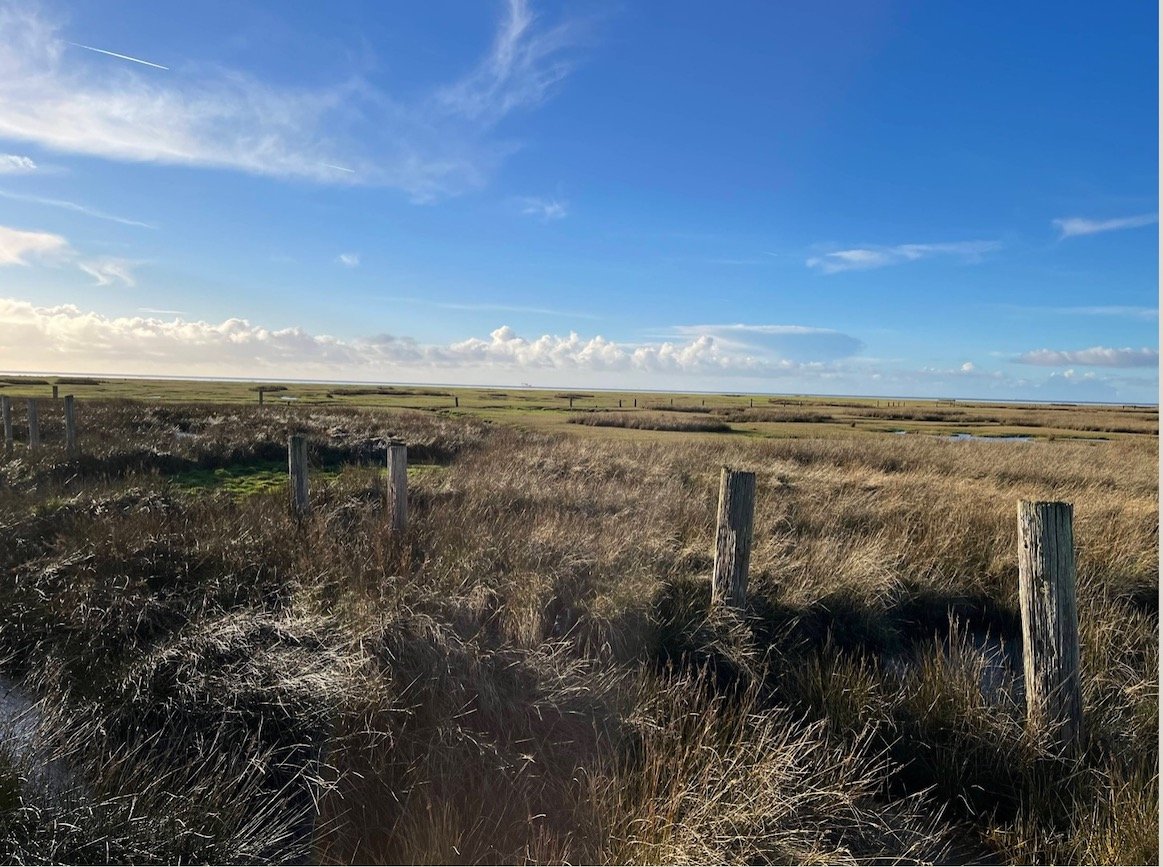
02 The Salt Marsh and ‘Baxter’s Rails’
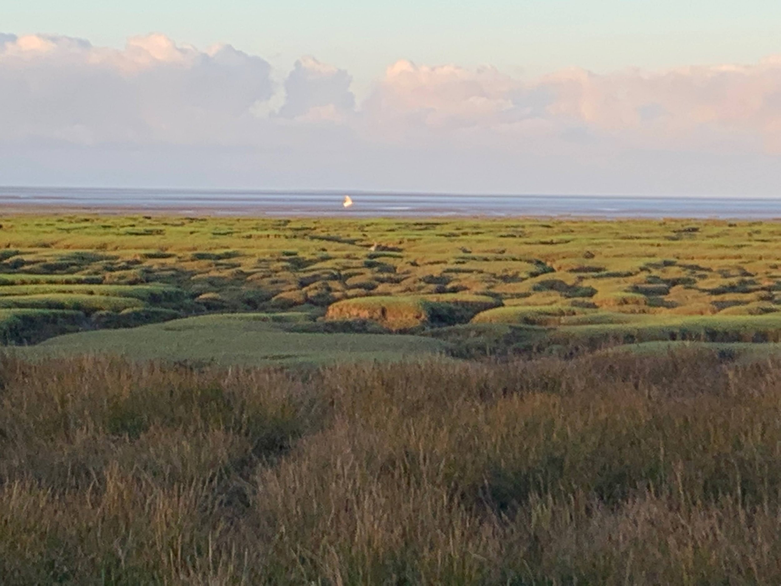
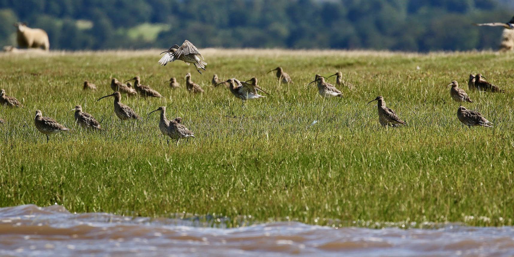
The Salt Marsh: The sands give way to the grasses and gullies of the salt marsh. With a rising tide you could be rewarded with hosts of wading birds zipping along the shoreline.

Wading birds use the mudflats and channels to feed. Morecambe Bay is a major food-stop for many thousands of birds in the migratory cycle. Watch out for Curlew – once an iconic bird of the British coast and countryside, it is a species in worrying decline, the Bay hosts large over-wintering flocks migrating into the Bay from Russia and Europe. Listen for their evocative haunting, rippling call. A little more on bird life.
‘Baxter’s Rails’: On the right, a number of railway sleepers driven into the marsh are visible. This marked out an area of grazing keeping livestock from straying into the rest of the marsh. Put in place more than a century ago they are known locally as ‘Baxter’s Rails’. For a bit more and the fabled Belted Beauty
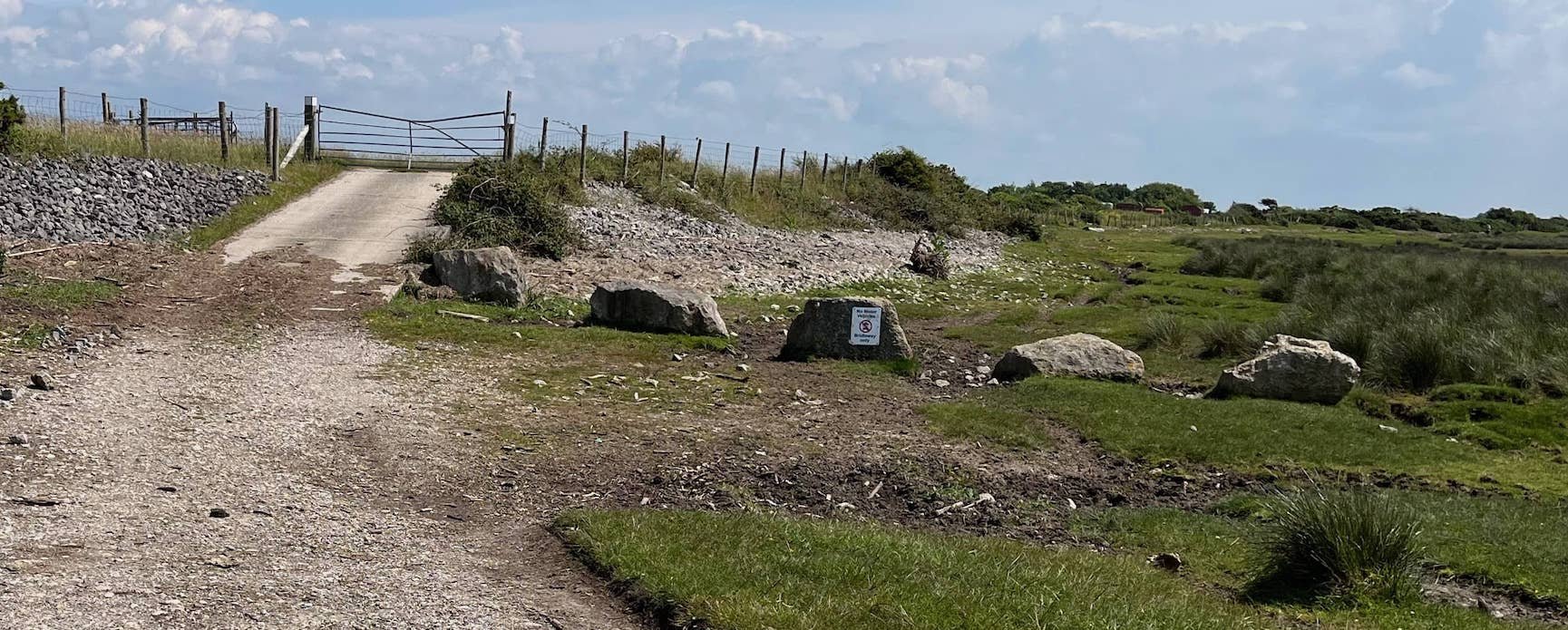
Directions: continue on the path until you reach the gate where the ‘Bridleway’ signpost points a left turn (towards Sunderland village). Enter through the gate and almost immediately turn right and through the swing-gate into the special enclosure where Bird Hide, Horizon Line Chamber and Gravesite are located.

03 The Bird Hide and the Horizon Line Chamber
Bird Hide: In 2017, when the new sea wall was built replacing the old wall destroyed in flooding, the opportunity was taken to site a bird hide. Much loved by keen birdwatchers, it is also used for research and entry is free to passers-by.
Horizon Line Chamber: The location was chosen by Morecambe Bay Partnership as part of their ‘Headlands to Headspace’ projects to install a land-art feature. They commissioned artist Chris Drury to design a ‘cloud chamber’, the domed building faces the sea with a lens set in the wall looking to the horizon. Inside the chamber this produces a magical (if inverted) view of the Bay.

You Tube video about the Chamber by artist Richard Shilling. Our articles on the Chamber here and here.
04 The Gravesite.
The much-visited Grave is an emotive place of local and national significance. For some it is a place of pilgrimage. In the past flowers were left on the grave, more recently it’s been painted stones and children’s ephemera, today some are leaving coins.

The traditional story is that the grave commemorates a probably enslaved black African, who shortly after arrival at Sunderland Point in 1736, died a lonely death in the brewhouse next to the Ship Inn. The epitaph on the brass plate was written by the Rev. James Watson some sixty years later. He was headmaster at the Grammar School with two brothers having leading roles in Lancaster’s slave trade.
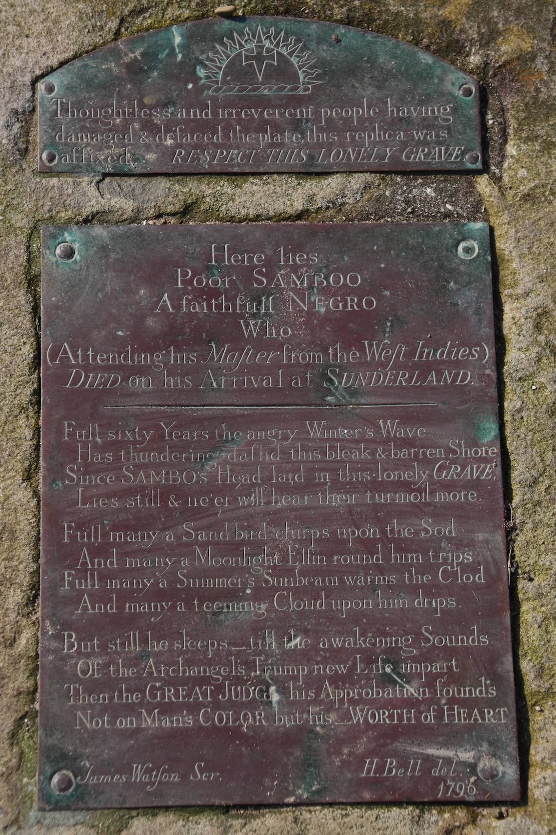
There is a comprehensive information board explaining this complex story. Article on the gravesite
Directions: Retrace your steps returning through the gates back to the shore. Continuing south, it is no longer a public footpath but a permissive path on the shore and there is no footpath through the fields. We rejoin the public path on the other side of the Point.
By now there is a good view of the lighthouse – an ideal guide to walk towards.
Pass through the gate where the path becomes very stony taking great care walking to the Point End.
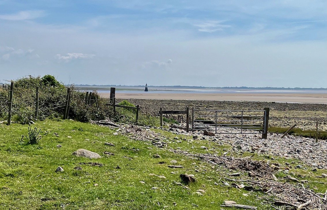
05 The Point End and Plover Scar Lighthouse
The Point End: Even in bad weather the views over the Lune estuary and the expanse of Morecambe Bay are amazing and uplifting - well worth the stone strewn walk. On a clear day Blackpool Tower is visible. There will be birds, certainly Oystercatchers and Gulls, perhaps Godwits, Dunlins and Redshanks.
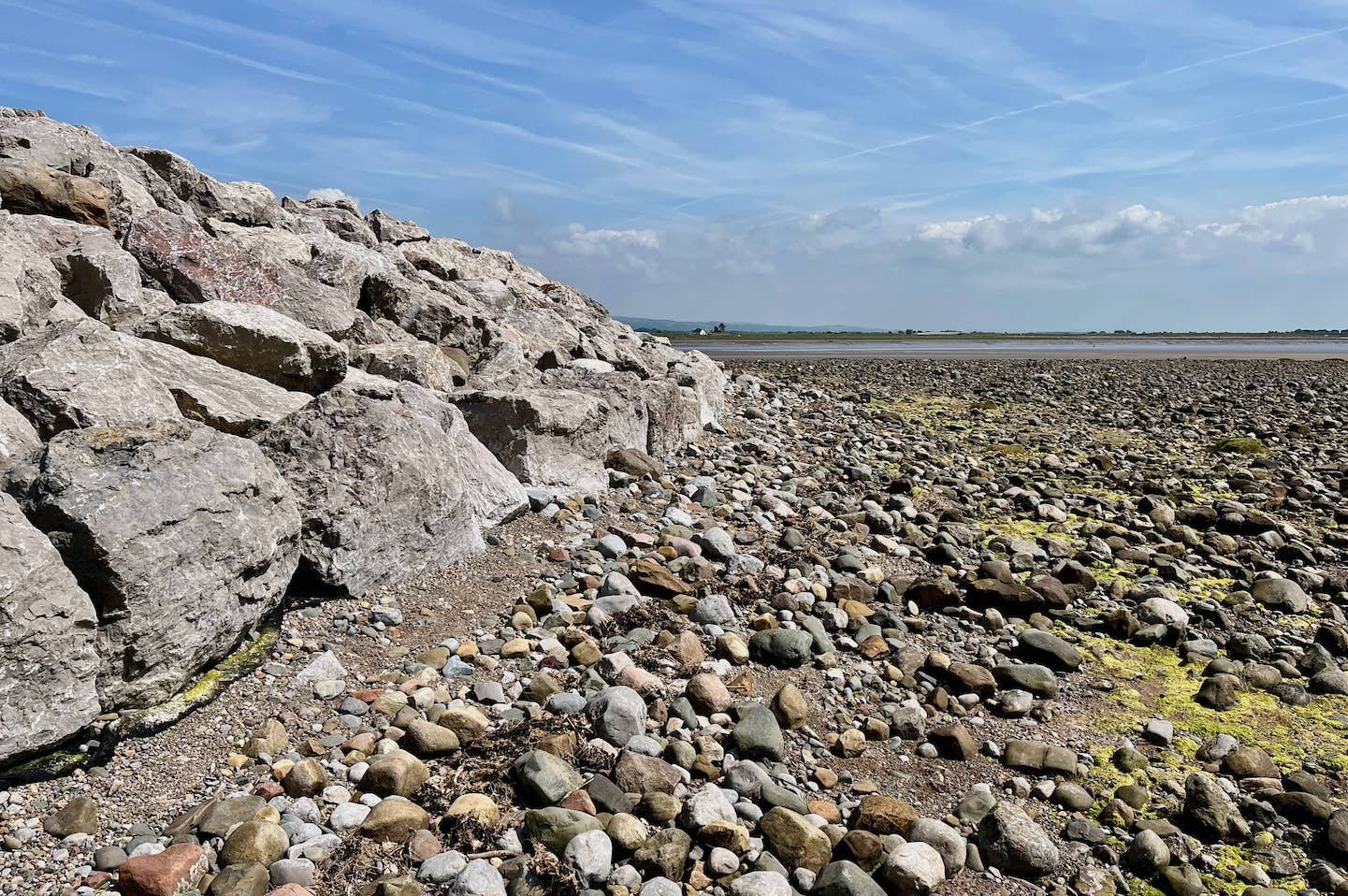
The huge limestone boulders surrounding the tip of the Point were laid in 2013 to halt the erosion that had been eating the land away at a rate averaging a metre a year. Erosion at the Point End
From here is the best view of the Lighthouse. This brilliant photo taken by Alan Smith is from the other side of the river.

Plover Scar Lighthouse: Originally built in 1847 as one of a pair of ‘leading lights’ the other was land based at Cockersand. Used together they provided navigation points for shipping entering the river heading for Glasson Dock.
Built on a rocky outcrop in the river, the lighthouse was oil fired until the early 1950’s and fully automated at the end of the decade. For the first hundred years it was tended by members of the Raby family.
Rounding the Point gives the first view of the Old Hall.
Directions: Continue round the Point keeping to the shore, the land is private and boulders dangerous to walk over. It can be hard going but persevere; the public footpath is soon rejoined. Getting close to the Old Hall, keep to the higher bank of shingle and notice steps leading onto a concrete wall. Continue until the main building is revealed.

06 The Old Hall (or Sunderland Hall)
This fascinating and attractive house is the oldest dated in the village. The main house was built in 1683 for Robert and Elizabeth Pearson. Born in Overton, Robert was a courageous master mariner and merchant who made some of the first transatlantic passages to Virginia on his ship Hope of Lancaster. He traded essentials such as cloth, coal, and felt hats to colonists in return for tobacco.
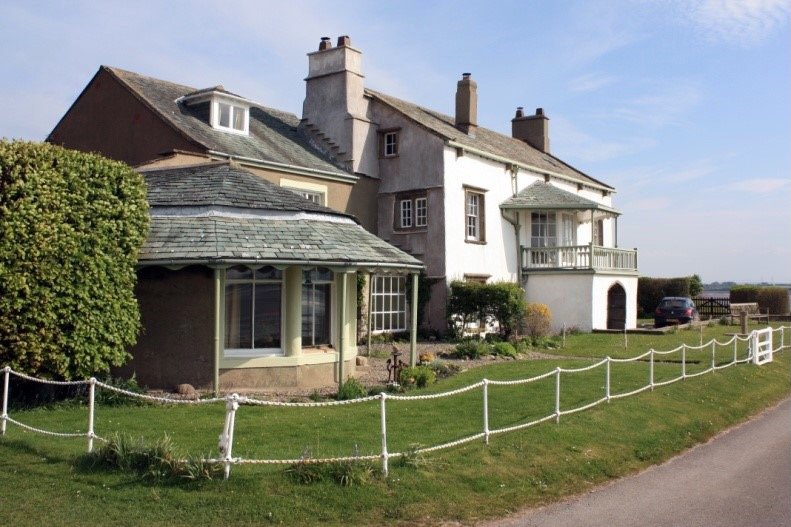
The house is best known as the home of merchant Robert Lawson responsible for much early building at the Point.
The decorative house attached dates from a century later, and was once the summer residence of James Williamson, father of namesake who became Lord Ashton, more popularly known from the family floor covering business as the ‘Lino King’.
Both generous benefactors to the city, with Williamson Park, the landmark memorial, and the Town Hall best known.
Directions: follow the path along the well-made track towards the village, a small black shed-like building soon appears on the left.
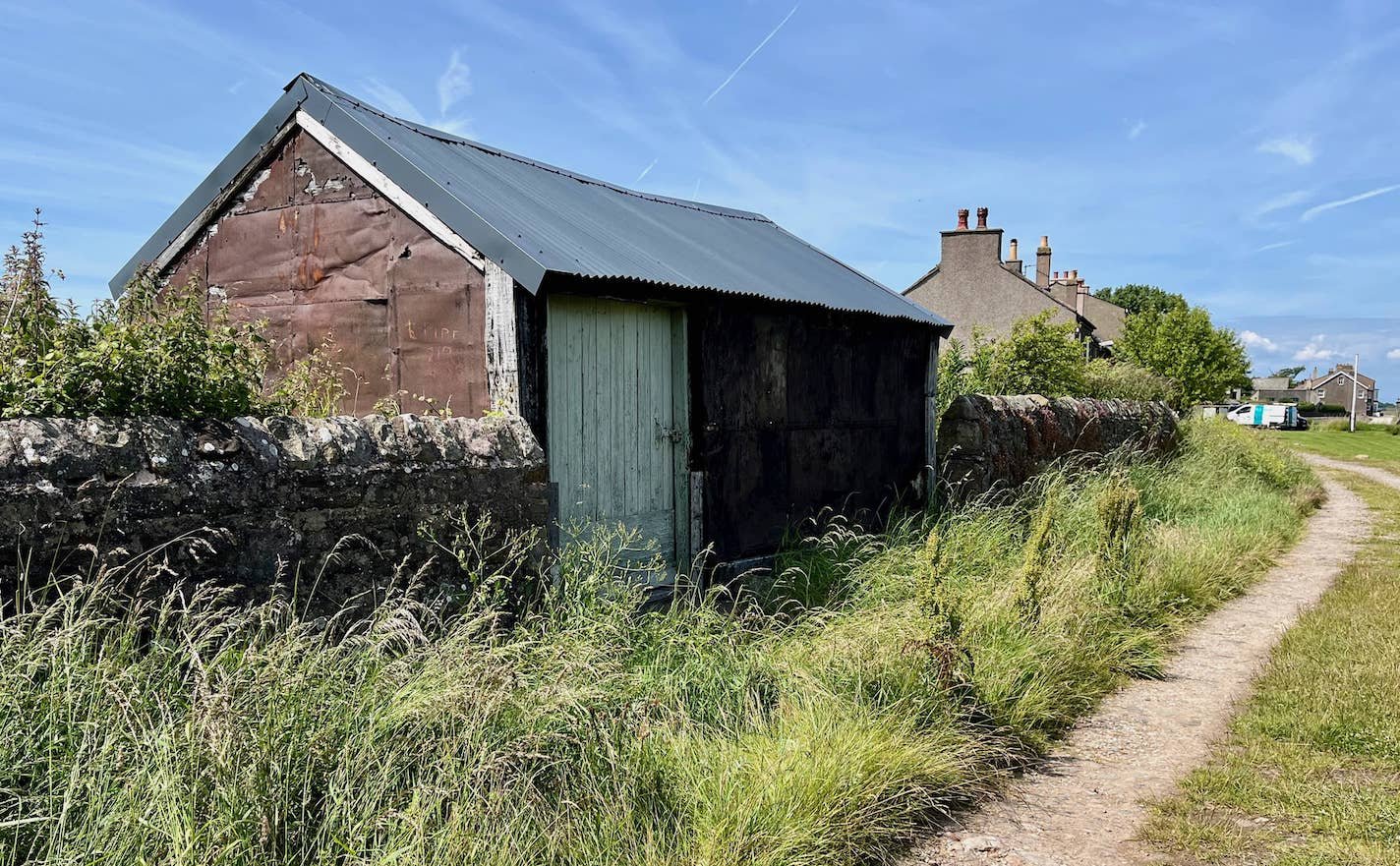
07 The Fish House and Net Posts
The Fish House (or hut) was built by local fisherfolks as a store for Salmon netting. On the opposite side of the track are the remnants of posts used to hang the nets to dry. Before the advent of synthetic fibres, nets survived longer if they were dried and cleaned at the weekends when salmon fishing was not permitted.
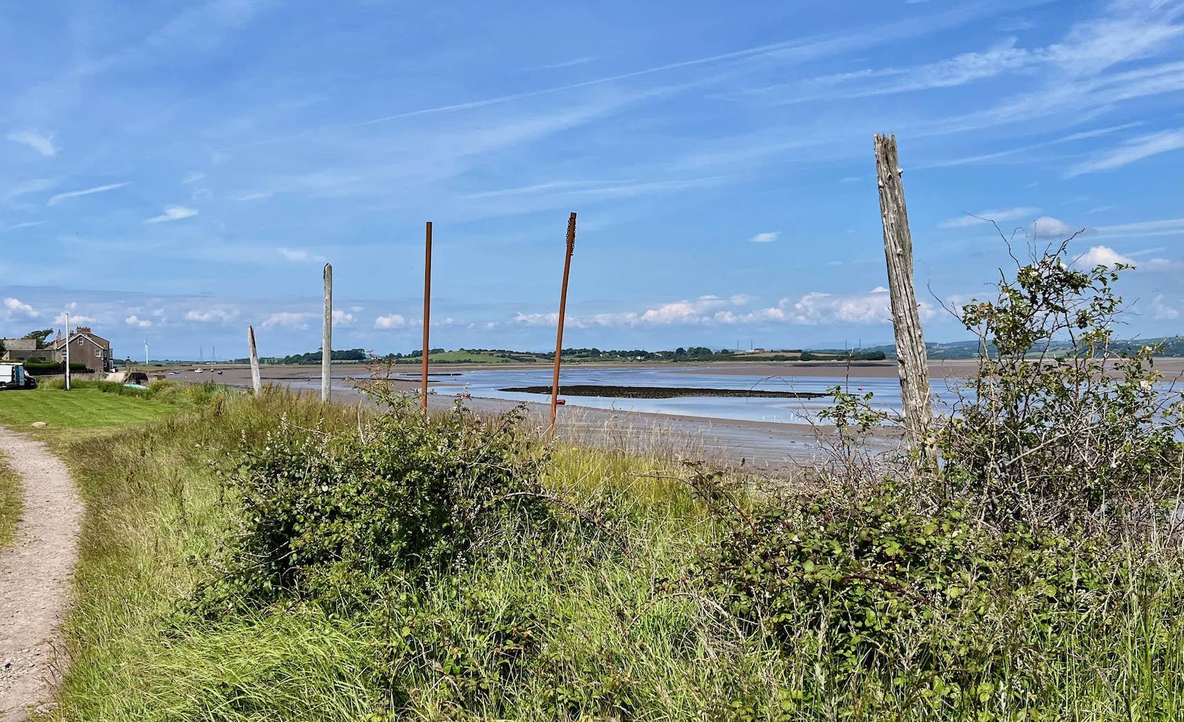
The Net Posts July 2024
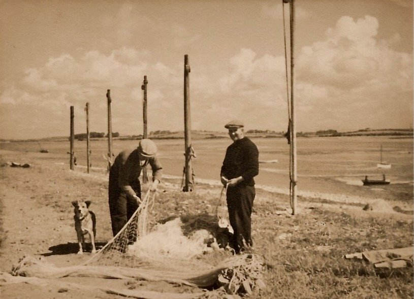
Hubert and Arnold Townley and dog at the Net Posts in 1945
Salmon numbers across the entire North Atlantic have been in calamitous decline for many years. There is a legal ban on Salmon netting in most British rivers including the Lune. This has ended the livelihood of families, some having lived on the Point for many generations.
For Salmon disappearance. Webpage on ‘Fishing’ at the Point.
Directions: keep going, pausing at the first house.
08 Cotton Tree Cottage and Cotton Tree
Cotton Tree Cottage: It is said that this delightful cottage was built by sea captain Thomas Weeton and his wife Mary in 1751. The letters W and T M unmissable on the date stone represent their names. Mary was a member of the well-known Quaker Rawlinson family merchants trading with the West Indies.
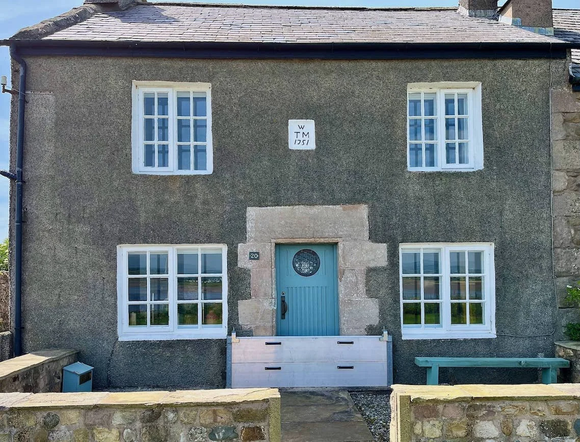
It’s not too difficult to imagine the couple at the house. Thomas supervises the loading of his ship moored in the river as it prepares for an Atlantic voyage. Mary packing his sea chest with clean clothes, linens and his favourite hat…
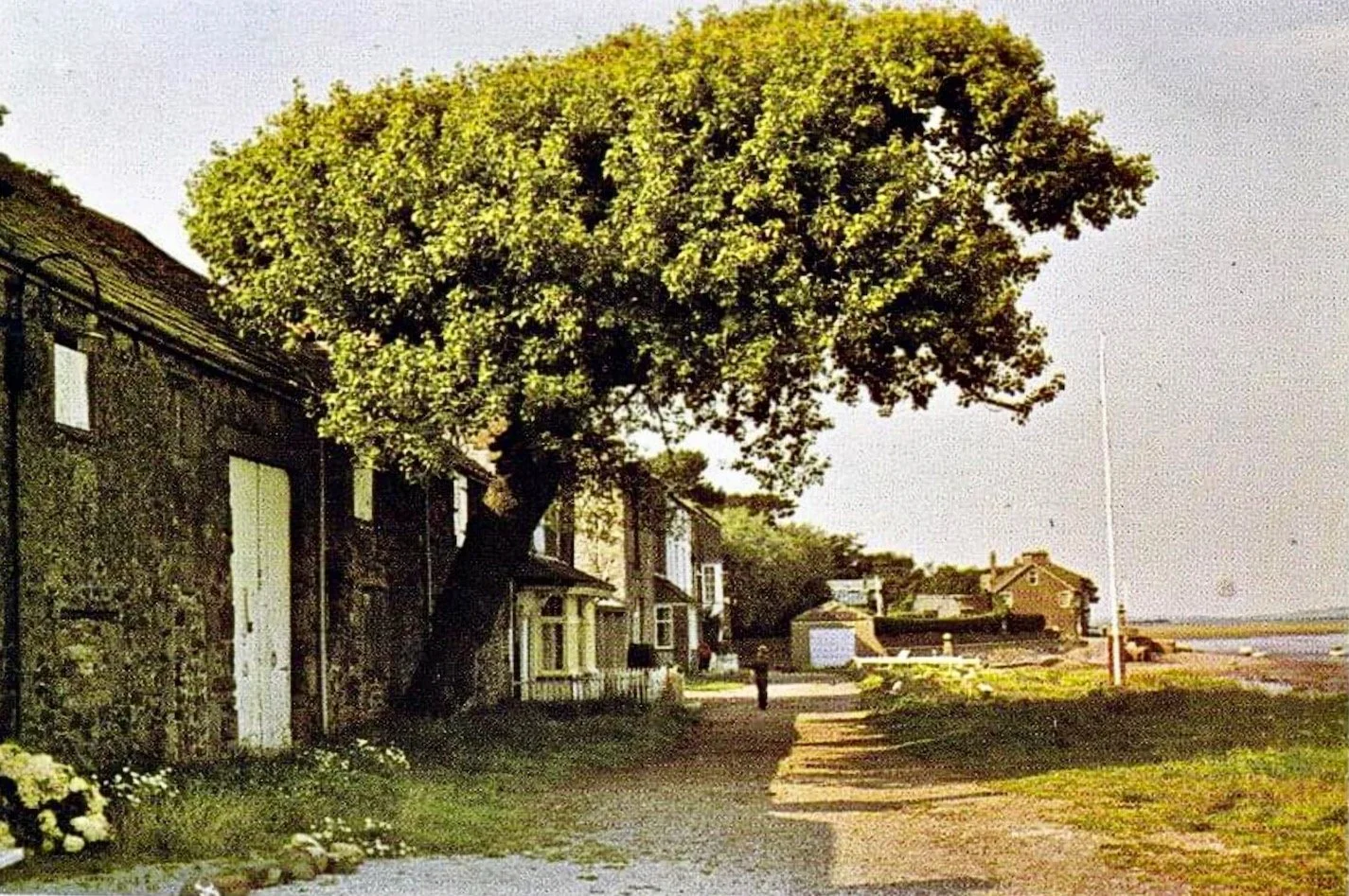
The Cotton Tree: Blown down in a gale on New Year's Day 1998, the well-known oddity earned its name from the fluffy cotton-like seed pods it produced each summer. The 250 year old tree, a female black poplar, had leaned precariously for many years. Young Black Poplars have appeared nearby and a slice of the old tree marks where it once stood.
09 The Big House, Reading Room and Second Terrace
The Big House: Another date stone, set into the wall to the left of the porchway, is less-distinctly dated 1715 with an L, I and M, signifying Joshua and Mary Lawson. Joshua, also a member of the mercantile Lawson family and Quaker, was father to Robert who we briefly met at the Old Hall.
The building, for many years just a shell, has maisonettes occupying the upper floors, and on most of the ground floor the Reading Room.

The Reading Room: Leased to residents of the village since 1910 it has an annual subscription of just £1. The past minute books record social events of all kinds including theatricals, lantern slide lectures, whist drives and the curiously named ‘potato and cake’ competitions. There never was an event like the New Years Eve parties.
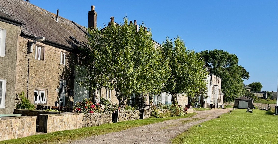
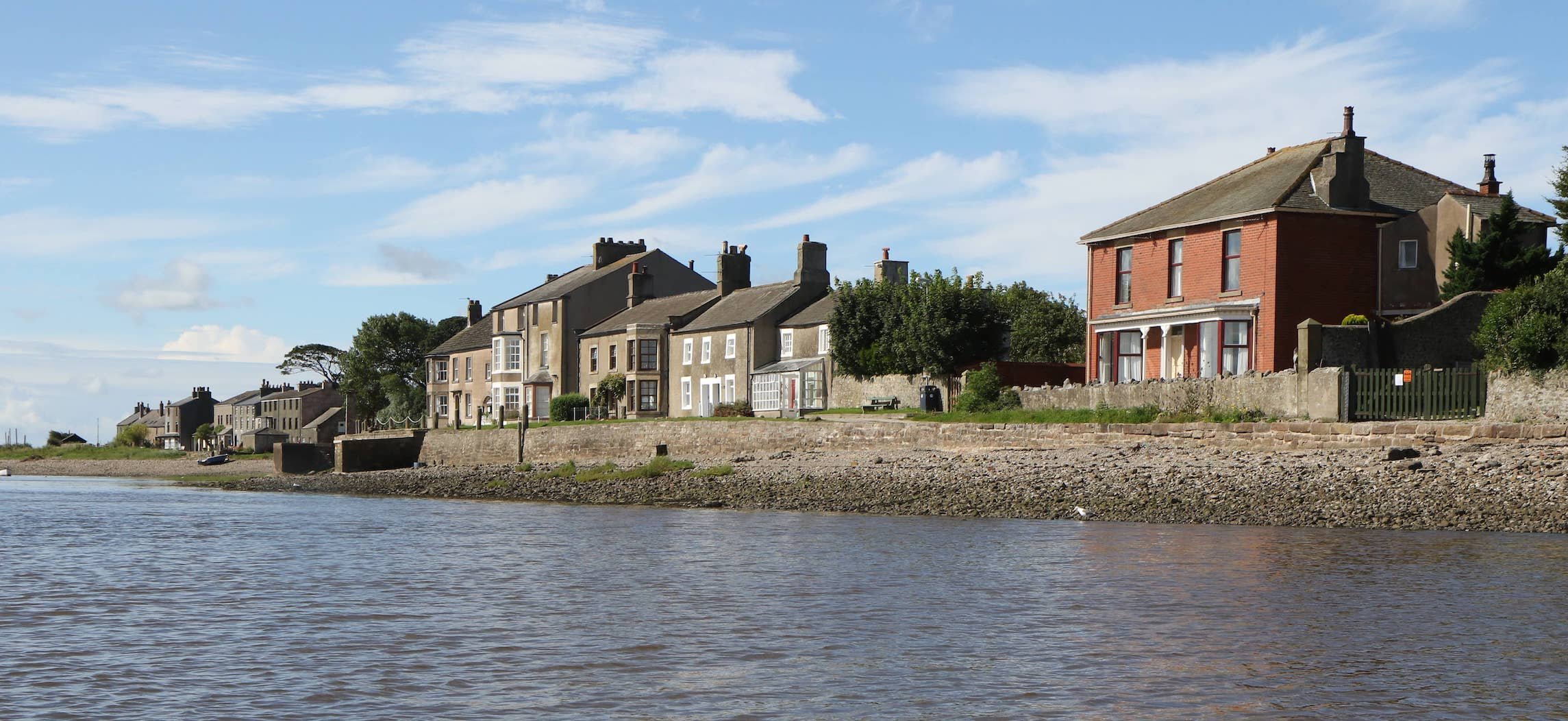
Second Terrace: Most of the buildings were originally warehouses. After the transfer of maritime trade to Glasson Dock in the 1790s, they were restored and repurposed as summer residences to enjoy brief success as a healthy and invigorating bathing resort earning the nickname ‘little Brighton by the sea’. Number 14 was a hotel under various names where hot and cold sea water bathing was offered to guests (in privacy) in the purpose-built bathhouse.

Notice Multum in Parvo the little house built to infill the space between numbers 14 and 16. In recent memory it was home to a family of seven.
Directions: continue walking on the ‘front’ to the end of the ‘Pad’, the raised pathway that joins First and Second Terrace.
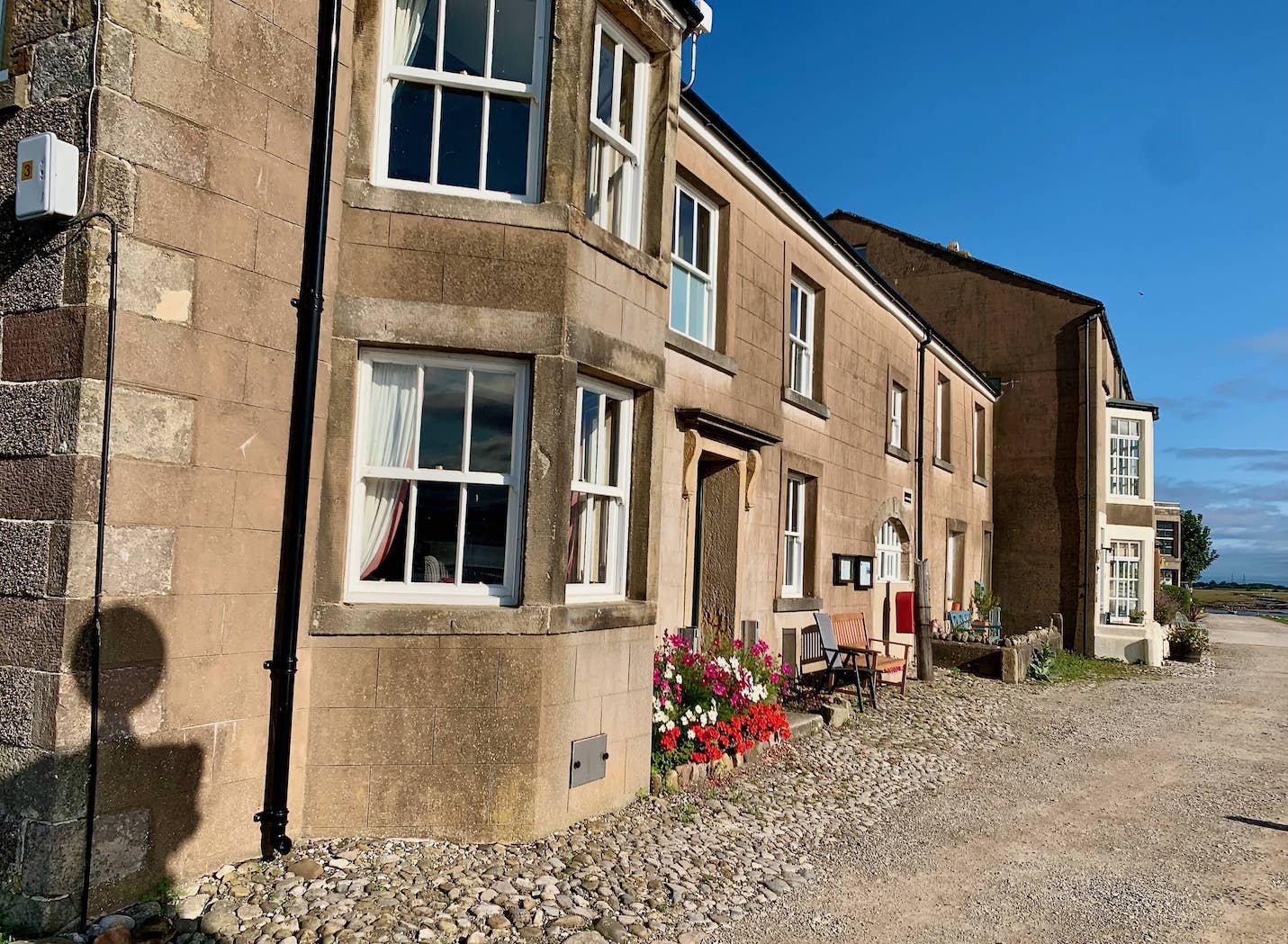
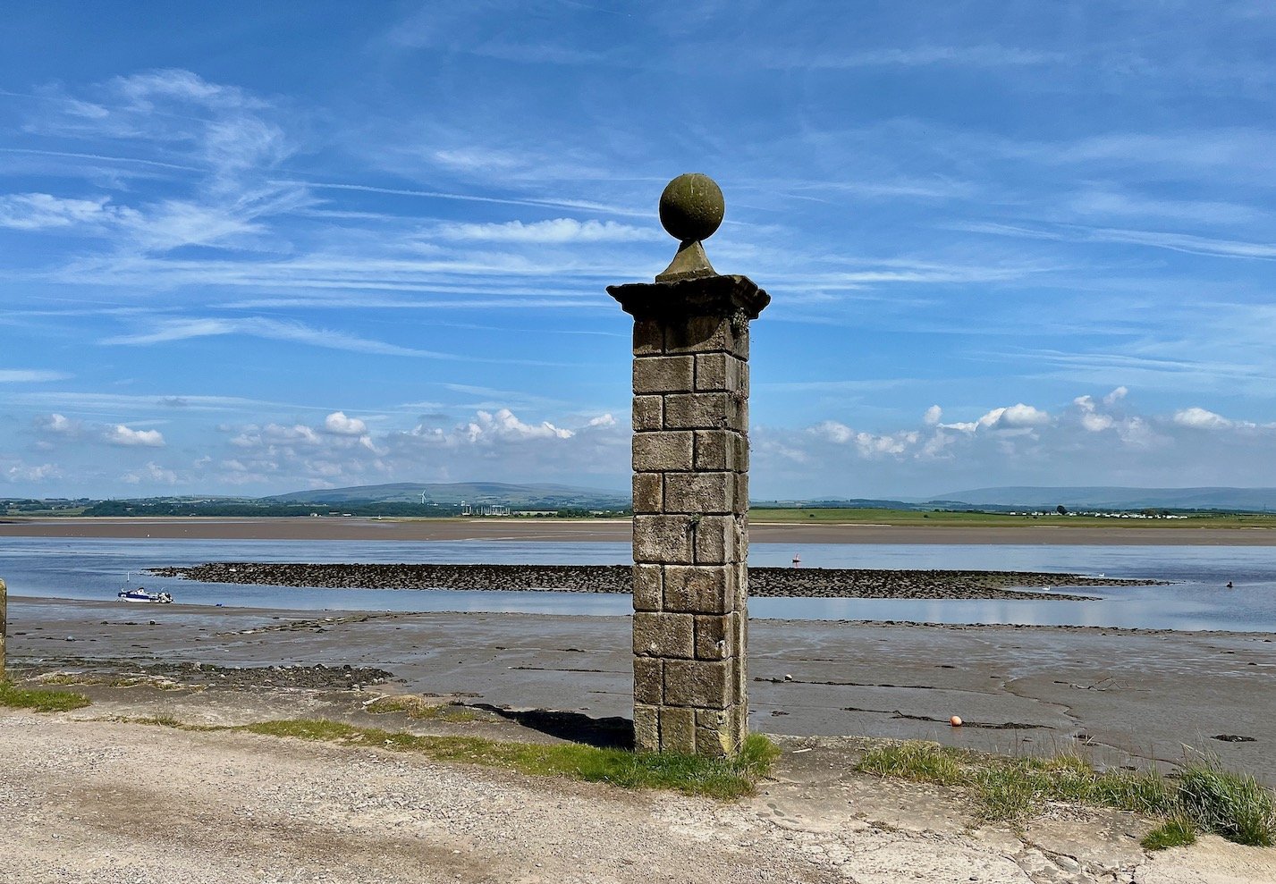
10. The Ship Inn, Stone Pillar and First Terrace.
The Ship Inn: The corner house was once the Ship Inn built to provide accommodation to visiting mariners and supply freshly brewed beer to departing ships. It lost its licence and name in the early 1860’s. Then as the Temperance Hotel it lasted until the early 1950s.
The Stone Pillar: Once part of a pair of gate posts at the entrance way of the old route (now the Wynt) to the merchant's lookout at the top of the Lane. Today it is frequently photographed in selfies with the river and Second Terrace in the background.
First Terrace: The other houses had uses as warehousing, farm buildings and shipwright's workshops. The grand red house at the end was built in 1890 by Robert Mansergh, a Lancaster oil cloth merchant - and keen teetotaller - as a summer residence. The house immediately next door set back from the track (used by Robert Mansergh’s coachman) is the old Custom House where a ‘tyde waiter’ (customs official) checked, taxed and recorded imported goods landed at the Point.
Directions: keep walking until the causeway and public toilets are in sight. Taking advantage of the facilities if needed.
11 The Causeway
Covered by the tide twice a day on most days, it is the only vehicle access to the village. In stormy weather the highest tides cover the road for more than five hours and deep enough to completely cover a car. It is the longest mainland tidal road in the country.
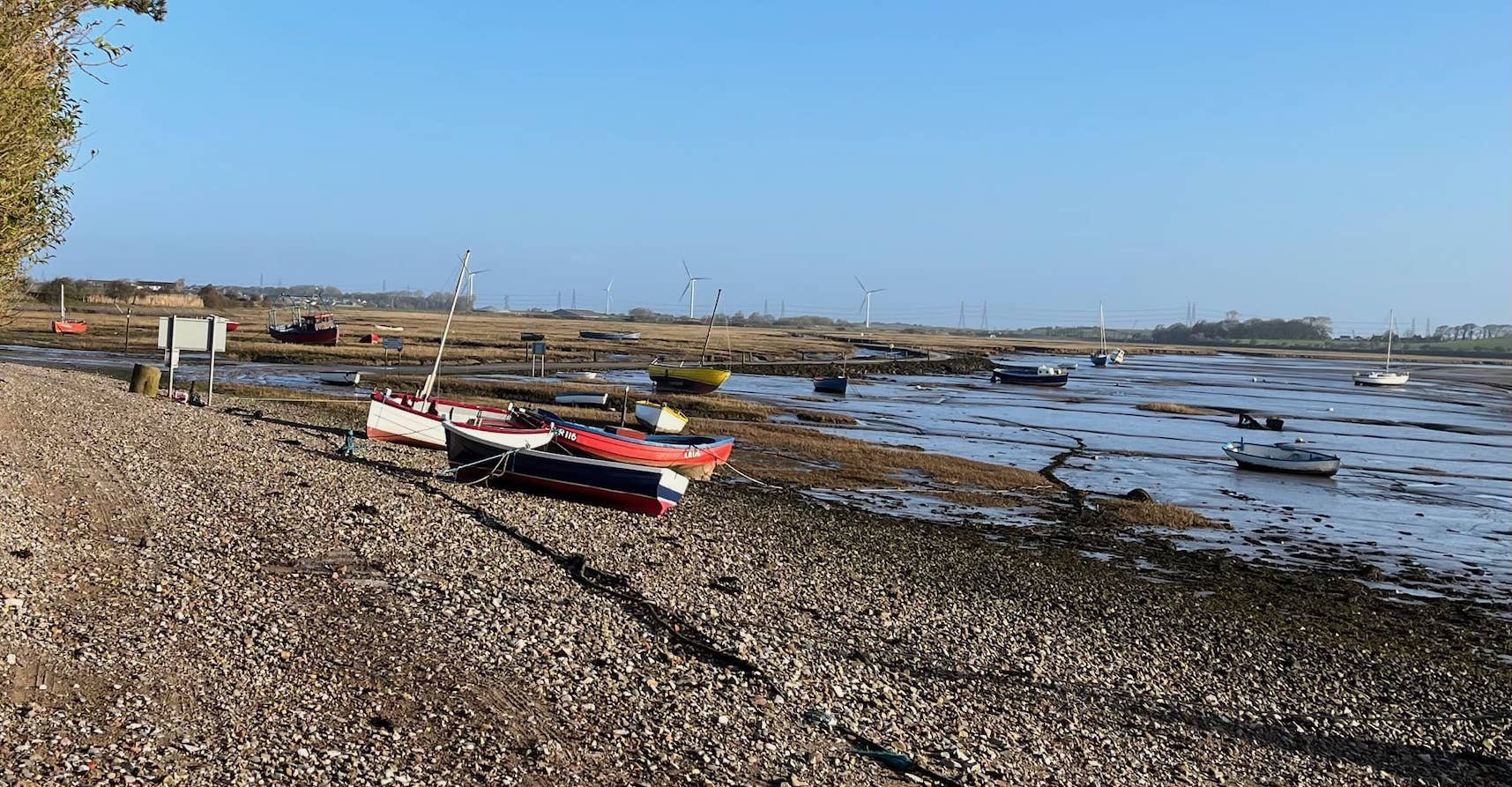
Every year cars and vans become stranded, some requiring rescue by coastguards. The road is muddy and potholed. We can trace livid complaints about the condition back to the 1730s. Residents have fallen out over proposals for a new tide free road, but a majority have always been opposed. It’s part of the magic.

Directions: retrace steps to the corner of First Terrace as it turns right into the Lane.
12 Upsteps Cottage
Immediately recognisable by the steps leading to the old front door. Once the Brewhouse it's here in the traditional story that the enslaved African dies in 1736. In the Point’s days as a health spa, sea water showers and baths were installed in the lower half of the building.

Directions: Walk to the top of the Lane, enjoy the panoramic views over the fields to the river and open sea.
13: The Mission Church and the Summer House
The Mission Church: opened in 1894 designed by famous church architects Austin, Paley and Austin. It provided religious services to residents and visitors for over a century. In 2017 residents arranged with the Church of England for its transfer into a charitable trust for future use by the community and public and as a heritage centre.
The Summer House: Built in early 18th century as a lookout tower for merchants watching nervously for the arrival of their ships after months-long perilous voyages. A compass dial was painted on the ceiling of the top room with an arrow attached to a weathervane on the roof. This gave the prevailing wind direction, helping merchants calculate when a ship would drop anchor and be ready for unloading.
Directions: continue down the Lane to the Gravesite and turn right returning along the shore towards Potts Corner where the walk started.
14 The Pillboxes and old Tram
The Pillboxes: They are more easily spotted walking in the return direction, keeping to the higher part of the banking they soon become visible. Two pillboxes were built to defend a WW2 Anti-aircraft gun emplacement sited to fire shells at German bombers flying overhead heading for Barrow-in-Furness. The supporting camp was big enough for a concert in 1942 starring George Formby. The Point and World Wars here and here.

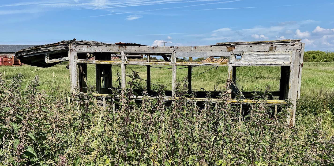
The Old Tram: The last fragments of an old tram can - just - be seen. Originally from Bradford Corporation Tramways, it was bought for use in the Holiday Camp in 1950. Later it was a changing room at a local cricket pitch, then moved here for storage by the nearby farm. There’s not much left…
(Note: the farmland is private and entry to the fields is forbidden)
From here it’s a short walk back to Potts Corner. The skyline is dominated by the unlovely Heysham Power Station2 - but it is considered to be the most productive nuclear powered generator of zero carbon electricity in the UK.
Look further In the distance and see the lovely Lake District hills.
We hope you enjoyed this short walk
For a printer friendly version of the walk which excludes the photographs.
Credits: Many thanks to Alan Smith (many of the photos), Paul Hatton (the map), Chris Hargreaves (permission and advice), Michael Morris (useful tips) and for help with editing and checking, thanks to Elizabeth, Katharine and Scottie. The OS map has been slightly modified for clarity.
This walk is loosely based on ‘To the Point’ a walk published by the Royal Geographic Society in their book and online ‘Discovering Britain’. We acknowledge the source and give thanks, however most of the material is original to us and is copyright.