The Legal Quays at Sunderland Point
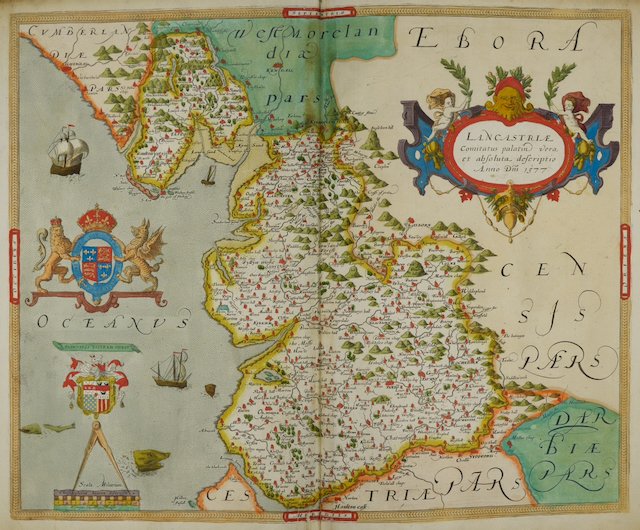
Saxtons map of Lancashire 1577: Source Wikimedia Commons
Hugh Cunliffe was heroic. He spent many hours in libraries leafing through papers, collecting information for his splendid book, The Story of Sunderland Point. In the first pages, he narrates the origins of the village and the development of the Port of Lancaster. Included are descriptions of the all-important legal quays where the tax-payable cargo was allowed to land or depart. His description is good, but it’s not clear where they were.
Fortunately, thanks to Doug Welch, we can now be much more precise about their likely location.
In this year’s edition of Contrebis (the journal of the Lancaster Historical and Archaeological Society), Doug has a paper discussing the progress of the legal quays in Morecambe Bay linked to the port of Lancaster, including Sunderland Point.
A legal Quay
Doug explains what is meant by a legal quay:
‘‘By 1560, every port, however minor, needed to be legal, that is, designated by the state as a precisely delineated place for the transfer, monitoring and, where necessary, taxing of goods or people in and out of the port’
He goes on to say:
‘In 1680, the Commission of the Exchequer took on the task of nationally delineating the limits of the ports under its control. Piel Island and Grange (-over-Sands) were the two existing creeks under Lancaster. To these was added Ashmidden (on the Sunderland peninsula)
The smaller legal quays often included open waters close to the shore where boats awaited inspection’.
Which we could imagine happened in the estuary in front of the Old Hall.
The first Legal Quay at Sunderland Point.
In 1681 in their list of legal quays, The Commissioners of the Exchequer defined the quay as:
“That open Place called the Ashmidden, lying opposite to William Garner’s House extending a hundred Yards along the Shore above the said House Northerly, and a hundred Yards below the said House Southerly, and bounded by the River Lune Easterly and the Shore Westerly”
Poor Hugh and us! This is a surprise, perhaps a bit of a bombshell; we have not heard of a William Garner (or Gardner) before nor any description of the Point as ‘Ashmidden’.
We know the place known as ‘Sunderland’ was in use in the 1570s when it was described as an area of 80 acres, eaten away by the tide and infested with rabbits (just like today!). On early maps, the location features as Sunderland Point (Poynt), suggesting the tip is an important navigation feature.
Detail from the map above that shows Sunderland ‘Poynt’ (Point)
The best we can do, as Doug does, is assume Mr Garner’s house was probably where the Old Hall is currently located. The specific location is an ‘ash midden’ that may have been named after the site of a midden used or previously used there rather than an alternative name for the place, Sunderland.
What is very important and intriguing is that the quay was in existence by 1681. We have no knowledge when it was first permitted - perhaps it was part of a network of quays around Morecambe Bay in medieval times. More research is needed.
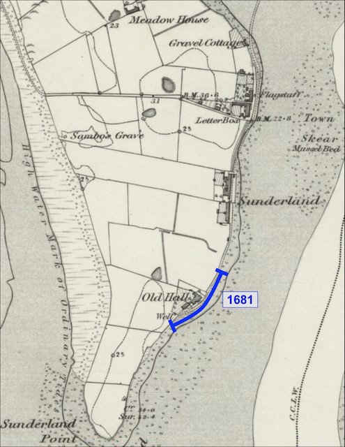
Taking the location as the Old Hall, we can plot the quay almost exactly.
Location of the first legal quay overlayed on the 1840s OS map: Courtesy National Library of Scotland. Illustration Paul Hatton.
Of the mysterious Mr Garner (or Gardner), Doug says this:
‘In the parish register of Overton, a William Garner was buried at Overton’s parish church of St Helens on 1 September 1683. It is likely he is the same person as the “William Gardner” with an administration bond dated 7 November 1683.’
This in itself does not tell us where William was living, but hearth tax records for Overton in 1664 show William Gardner as one of only two Overton tenants possessing four hearths. We can assume his house was substantial by Overton standards, a building that could be used as a landmark for shipping.
Golly. Much more research is needed.
There is no archaeological or other evidence of this earlier house at SP. In the 1670s, John Hodgson and others, including the Lawson family, began trading with the plantation colonies from the Port of Lancaster. Also included was merchant and master mariner Robert Pearson—who built the Old Hall—who was heavily involved with Hodgson and the Lawsons. Our article on the Will of Elizabeth Pearson and the inventory of Robert Pearson covers this period.
As trade gradually increased, local warehousing began to be built, most probably for the low-value staples to be shipped out. It is imagined that the valuable incoming cargo was quickly whisked up to Lancaster or onto boats headed elsewhere around the coast. This gradual expansion led to a new location for the quay.
The second Legal Quay at Sunderland Point.
Designated in 1723 by the Commissioners of Customs (and replacing the first), the description of the location is as follows:
“And also, that open place at Sunderland formerly called the Ash Middins extending 400 yards from the North to South one half above and one half below the Centre of Mr. Lawson’s house and bounded on the East by the River Loyne and on the West by the said House of Mr Lawson in Sunderland and other houses there belonging to Mr. Lawson”
This is a little difficult to understand on first reading, it says that half of the quay is to the south of Mr Lawson’s house and the other half to the north. Four hundred yards in total. But which Mr Lawson? And which house?
We think that after the death of Robert Pearson in 1687, the Old Hall was taken over by the Lawson family, becoming one of the homes of Joshua Lawson. In 1715, Joshua built the ‘Big House’ – today, the property occupied by two maisonettes and the Reading Room – where Joshua may have lived. Around the same time, his son Robert married Mercy Moss in 1716 and moved into the Old Hall.
But which Lawson house?
Joshua was key to the Lawson business, a mariner and merchant with vast experience and a leading figure in Lancaster. Since he was still alive in 1723, we suggest it must have been his house. Like the satisfying crisp snap of a jigsaw piece falling into place, we think this proves it.
Using this house as the centre point and following the description above, it fits neatly at the north end of the 1681 legal quay and snugly at the north end of the Pad before the junction of the Lane and First Terrace.
Location of the 1723 second legal quay overlayed on the 1840s OS map: Courtesy National Library of Scotland. Illustration Paul Hatton
This suggests the locus of the business moved from the Old Hall to Joshua’s new house; perhaps the Second Terrace warehouses were built on either side of the ‘Big House’, maybe the house itself was in part a warehouse.
Smaller boats could move from shore to ship along this strip, making good use of the gentler slope of the shore in front of what is today the garden of Dolphin House, number 12.
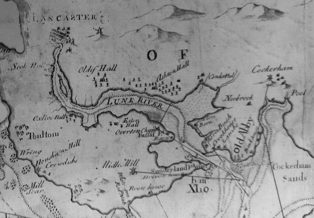
The Point was growing in importance, as this rather unusually angled map suggests.
Fearon and Eye’s map of 1738, showing Sunderland Point from Doug’s Contrebis article. It is just possible to spot buildings, and the Merchants look out: With the permission of Lancaster City Museums.
The third and last Legal Quay at Sunderland Point.
With regular voyages to the West Indies adding to those to North America, the pace of transatlantic trade was accelerating, and 13 years later, in 1739, the third quay was designated superseding the two others..
Doug explains: ‘The boundaries extended even further in 1739, much further north, taking in an area 510 yards long with stone boundary markers north and south.’ This is both interesting and important, like Hugh had done before us, we wanted to see the full quote. We ordered a copy of the source material at modest expense.
Transactions of the Lancashire and Cheshire Antiquarian Society 1945-1946
From the article ‘Some Early Records of the Port of Lancaster’ by Rupert Charles Jarvis F.S.A. F.R.Hist.S.
The full description is as follows:
“All the open space at Sunderland aforesaid belonging to Mr Richard Birkett and in possession of James Nicholson Mariner markt. “S.1739” thence Northwards to a certain other Stone Post or Boundary fixt opposite to the North end of a certain Blockmakers Shop at Sunderland aforesaid belonging to Mr Robert Lawson markt “N.1739” in length from North to South about 510 yards and bounded on the East side by the River Loyne and on the West side by the Houses and lands at Sunderland aforesaid.”
As the southern boundary marker stone still exists (and assuming it has not been moved), it is easy to step out 510 yards and locate the northern boundary of the final quay.
The South boundary stone is heavily eroded, but bright sunshine picks out the large letter ‘S’ and the year 1739.
Location of the 1739 third legal quay overlayed on the 1840s OS map: Courtesy National Library of Scotland. Illustration Paul Hatton
The quay now covers Second Terrace and the length of First Terrace to where the track from Overton rises onto the Point. Looking closely at the map, it shows that Gravel Cottage is just within the northern boundary.
According to Robert Lawson’s will and title deeds, this property once belonged to him and was known as the 'little warehouse’ at the time of his death in the 1770s. Perhaps we have identified Gravel Cottage as once being ‘a certain Blockmakers Shop at Sunderland aforesaid belonging to Mr Robert Lawson’.
Early photo of Gravel Cottage, for many years the first property at the end of the track from Overton: From the collection of Hugh Cunliffe
Also within the northern extent of the quay is Old Customs House (3A).
While the Sunderland peninsula was an important maritime base for seventy or so years, its slide into anonymity began around 1750 with improvements to navigation to Lancaster. The final curtain on cargo transfer came down with the opening of the dock at Glasson in 1782.
We are greatly indebted to Doug Welch, who has allowed us to use the information he has gathered. He also kindly reviewed this article, making helpful suggestions for correction. The full article is available in the current edition of Contrebis, the Journal of the Lancaster Archaeological and Historical Society. Unfortunately, it is not yet available on the Internet.
Special thanks also to Paul Hatton for the location drawings of the quays


